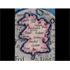
Frisland Map Decoded = Ireland... Duh (youtube.com)
submitted 6.4 years ago by PangaeaRepublic
view the rest of the comments →
PangaeaRepublic 6.4 years ago
Once you see it, haha... I believe the exact shape match using 6,200 BC sea levels suggests it was that old of a source map... right after the Storegga Slide and mt. Etna eruption... and formation of the English channel... this all lines up my doods
NEW THEORY FROM THIS: Atlantis Map Encryption https://youtu.be/TJSqP4usJVI
Check out the mirror reflection image, fixes my confusion on the diagonal part... it was copied like this https://imgur.com/j18VzSW
view the rest of the comments →
PangaeaRepublic ago
Once you see it, haha... I believe the exact shape match using 6,200 BC sea levels suggests it was that old of a source map... right after the Storegga Slide and mt. Etna eruption... and formation of the English channel... this all lines up my doods
PangaeaRepublic ago
NEW THEORY FROM THIS: Atlantis Map Encryption https://youtu.be/TJSqP4usJVI
PangaeaRepublic ago
Check out the mirror reflection image, fixes my confusion on the diagonal part... it was copied like this https://imgur.com/j18VzSW